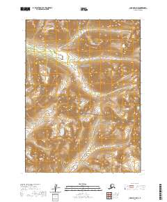
2020 Map of Iliamna D-3 NW
USGS Topo · Published 2020About this map
The Aleutian Range dominates this landscape within the Lake Clark National Preserve, where high-altitude peaks and glacial drainages define the wilderness of the Lake and Peninsula Borough. The map detail highlights the intricate drainage systems of Canyon Cr and Knutson Cr as they cut through the steep contours of the southern Alaska interior. The absence of roads or established settlements reflects the remote, protected status of this region, which is managed primarily for its natural and cultural resource preservation. Instead of human infrastructure, the terrain itself is the primary focus, revealing the complex topography and hydrological patterns that characterize the area's transition from mountain peaks to lower-lying valleys. This survey is a focused study of the undeveloped backcountry in the eastern portion of the preserve.
Find a feature on this map
8 named features on this map. Tap any name to fly to it.
Don’t see what you’re looking for? This feature index may not catch every label — zoom into the map to look around manually.
Map Details
Editions of this 2020 Iliamna D-3 NW Map
This is the sole edition of this map. No revisions or reprints were ever made.
Other maps of this area

1946 · Lake Clark
USGS Topo · 1:250,000

1951 · Lake Clark
USGS Topo · 1:250,000

1952 · Iliamna
USGS Topo · 1:250,000

1954 · Lake Clark A-3
USGS Topo · 1:63,360

1954 · Iliamna D-3
USGS Topo · 1:63,360

1954 · Iliamna D-4
USGS Topo · 1:63,360

1954 · Lake Clark A-4
USGS Topo · 1:63,360

1957 · Iliamna
USGS Topo · 1:250,000

1958 · Lake Clark
USGS Topo · 1:250,000
2018 · Iliamna D-3 SE
USGS Topo · 1:25,000