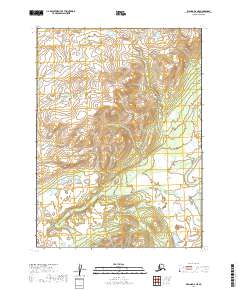
2019 Map of Iliamna D-6 NE
USGS Topo · Published 2019About this map
Nondalton occupies a prominent position on the eastern edge of this landscape, marking a vital point of human presence in the Lake and Peninsula Borough. The terrain is characterized by complex hydrology, with the Newhalen River winding through the southeastern quadrant, surrounded by a dense network of wetlands and small water bodies. This 2019 survey reflects the region's contemporary geography, detailing the land divisions within townships such as t2s r33w and t3s r33w. The map illustrates the balance between the established settlement of Nondalton and the surrounding natural drainage patterns, providing essential data for understanding the modern footprint of this Alaskan interior region.
Find a feature on this map
6 named features on this map. Tap any name to fly to it.
Don’t see what you’re looking for? This feature index may not catch every label — zoom into the map to look around manually.
Map Details
Editions of this 2019 Iliamna D-6 NE Map
This is the sole edition of this map. No revisions or reprints were ever made.
Other maps of this area

1946 · Lake Clark
USGS Topo · 1:250,000

1951 · Lake Clark
USGS Topo · 1:250,000

1952 · Iliamna
USGS Topo · 1:250,000

1954 · Lake Clark A-6
USGS Topo · 1:63,360

1954 · Lake Clark A-5
USGS Topo · 1:63,360

1954 · Iliamna D-5
USGS Topo · 1:63,360
1954 · Iliamna D-6
USGS Topo · 1:63,360

1957 · Iliamna
USGS Topo · 1:250,000

1958 · Lake Clark
USGS Topo · 1:250,000
2018 · Iliamna D-5 NW
USGS Topo · 1:25,000