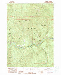
1989 Map of Illahee Rock
USGS Topo · Published 1990About this map
The Umpqua River snakes through a landscape defined by dramatic geological formations and early hydroelectric development. The Soda Springs Power Plant sits along the river's northern bank, marking a point of industrial utility amidst the protected reaches of the Umpqua National Forest. To the north, the Boulder Creek Wilderness preserves a series of drainage basins, including Onion Creek and Rattlesnake Creek, which descend from high points like Harding Butte and Illahee Rock. Cultural significance is evident at the Dog Creek Indian Caves and the small settlement at Illahee, situated near the river's bend. Low-lying areas like Illahee Flats and Oak Flats provide rare level ground between the ridges, while crossings like the Marsters Bridge and various gaging stations reflect the ongoing management of this river corridor.
Find a feature on this map
51 named features on this map. Tap any name to fly to it.
Don’t see what you’re looking for? This feature index may not catch every label — zoom into the map to look around manually.
Map Details
Editions of this 1989 Illahee Rock Map
This is the sole edition of this map. No revisions or reprints were ever made.
Other maps of this area

1917 · Diamond Lake
USGS Topo · 1:125,000

1955 · Quartz Mtn
USGS Topo · 1:62,500

1955 · Illahee Rock
USGS Topo · 1:62,500

1956 · Toketee Falls
USGS Topo · 1:62,500

1956 · Garwood Butte
USGS Topo · 1:62,500

1958 · Roseburg
USGS Topo · 1:250,000

1959 · Roseburg
USGS Topo · 1:250,000

1978 · Diamond Lake
USGS Topo · 1:100,000
1986 · Toketee Falls
USGS Topo · 1:24,000
1986 · Staley Ridge
USGS Topo · 1:24,000