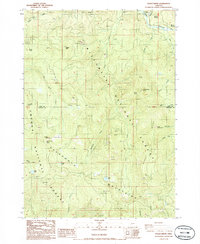
1986 Map of Staley Ridge
USGS Topo · Published 1986About this map
The Calapooya Mountains and Staley Ridge form the structural backbone of this 1986 survey, marking the rugged divide between the Willamette National Forest and the Umpqua National Forest. The landscape is defined by its dramatic vertical relief and numerous openings in the timber, such as Bristow Prairie, Ranger Prairie, and the aptly named Big Pine Opening. High-altitude water features like Bradley Lake, Fuller Lake, and the clustered Loletta Lakes sit tucked between prominent geological landmarks including Steeple Rock and Bulldog Rock. This provisional mapping effort captures a mid-1980s snapshot of an active timber and resource management area, evidenced by the proliferation of gravel and borrow pits alongside established sites like Campers Flat and Bear Camp along the Middle Fork Willamette River drainage.
Find a feature on this map
42 named features on this map. Tap any name to fly to it.
Don’t see what you’re looking for? This feature index may not catch every label — zoom into the map to look around manually.
Map Details
Editions of this 1986 Staley Ridge Map
This is the sole edition of this map. No revisions or reprints were ever made.
Other maps of this area

1917 · Diamond Lake
USGS Topo · 1:125,000

1925 · Waldo Lake
USGS Topo · 1:125,000

1935 · Lowell
USGS Topo · 1:96,000

1942 · Lowell
USGS Topo · 1:125,000

1955 · Illahee Rock
USGS Topo · 1:62,500

1955 · Fairview Peak
USGS Topo · 1:62,500

1956 · Toketee Falls
USGS Topo · 1:62,500

1956 · Oakridge
USGS Topo · 1:62,500

1958 · Roseburg
USGS Topo · 1:250,000

1959 · Roseburg
USGS Topo · 1:250,000