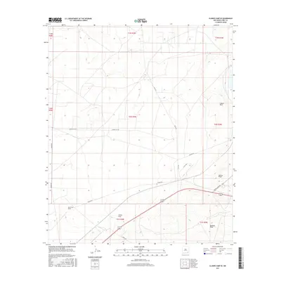
2017 Map of Illinois Camp SE
USGS Topo · Published 2017About this map
The arid drainage patterns of Fenton Draw and Lone Tree Draw define this portion of Eddy County, illustrating the sparse but vital watercourse system of the northern Chihuahuan Desert. This 2017 survey by the U.S. Geological Survey documents a landscape shaped by industrial access and topographical relief, notably at Mimosa Ridge and Quahada Ridge. The road network, including Buckeye Rd and Potash Mines Rd, highlights the region's connection to local resource extraction and infrastructure. Further north, the broad depression of Clayton Basin sits amidst the township and range divisions of T19S and T20S. The map serves as a contemporary record of how transportation corridors like Burton Flats Rd and Magnum Rd navigate the undulating terrain of this New Mexico desert landscape.
Find a feature on this map
20 named features on this map. Tap any name to fly to it.
Don’t see what you’re looking for? This feature index may not catch every label — zoom into the map to look around manually.
Map Details
Editions of this 2017 Illinois Camp SE Map
This is the sole edition of this map. No revisions or reprints were ever made.
Other maps of this area
1939 · Carlsbad
USGS Topo · 1:62,500
1939 · Nash Draw
USGS Topo · 1:62,500
1942 · Clayton Basin
USGS Topo · 1:62,500
1943 · Carlsbad
USGS Topo · 1:62,500
1943 · Clayton Basin
USGS Topo · 1:62,500
1943 · Oil City
USGS Topo · 1:62,500
1943 · Nash Draw
USGS Topo · 1:62,500

1954 · Carlsbad
USGS Topo · 1:250,000

1954 · Hobbs
USGS Topo · 1:250,000

1958 · Carlsbad
USGS Topo · 1:250,000