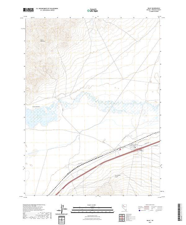
2021 Map of Imlay
USGS Topo · Published 2021About this map
Imlay stands as a primary focal point in this portion of Pershing County, situated near the transition from the high desert floor to the steep elevations of the Eugene Mountains. The landscape is dominated by the sprawling waters of the Rye Patch Reservoir and the adjacent Lassens Meadows, which together create a significant hydrological feature in an otherwise arid environment. This 2021 survey illustrates a modern infrastructure network, with local routes like Lake Rd and Callahan Rd connecting to the larger corridor of Frontage Rd and the Nevada California transit line.
Find a feature on this map
19 named features on this map. Tap any name to fly to it.
Don’t see what you’re looking for? This feature index may not catch every label — zoom into the map to look around manually.
Map Details
Editions of this 2021 Imlay Map
This is the sole edition of this map. No revisions or reprints were ever made.
Other maps of this area

1931 · Lovelock
USGS Topo · 1:250,000

1935 · Lovelock
USGS Topo · 1:250,000

1939 · Eugene Mountains Area
USGS Topo · 1:62,500

1942 · Eugene Mountains Area
USGS Topo · 1:62,500

1955 · Lovelock
USGS Topo · 1:250,000

1956 · Imlay
USGS Topo · 1:62,500

1959 · Lovelock
USGS Topo · 1:250,000

1971 · Rye Patch Reservoir South
USGS Topo · 1:24,000

1971 · Rye Patch Reservoir North
USGS Topo · 1:24,000
1971 · Alpha Mountain
USGS Topo · 1:24,000