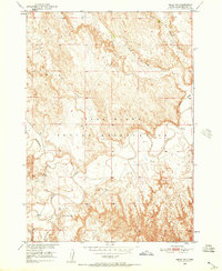
1950 Map of Imlay SW
USGS Topo · Published 1957About this map
The Pine Ridge Indian Reservation occupies the center of this 1950 field-checked survey, dominated by the winding course of the White River. The landscape is defined by the sharp transition from tablelands down to the river valley, where numerous seasonal drainages like Big Hollow Creek, Wind Creek, and Spring Creek have carved deep incisions into the local topography. For genealogists and local historians, the presence of the St Mary Magdalene Cem in the southwestern corner near Porcupine Cr provides a specific point of interest in this rural landscape. The drainage patterns of Cottonwood Creek and other tributaries illustrate the natural erosion processes of the Missouri River Basin development area during the mid-twentieth century.
Find a feature on this map
8 named features on this map. Tap any name to fly to it.
Don’t see what you’re looking for? This feature index may not catch every label — zoom into the map to look around manually.
Map Details
Editions of this 1950 Imlay SW Map
3 editions found
Other maps of this area

1950 · Sheep Mountain Table
USGS Topo · 1:24,000

1950 · Stirk Table
USGS Topo · 1:24,000

1950 · Imlay SW
USGS Topo · 1:24,000

1950 · Imlay
USGS Topo · 1:24,000

1950 · Imlay SE
USGS Topo · 1:24,000

1950 · Bouquet Table
USGS Topo · 1:24,000

1951 · Sharps Corner
USGS Topo · 1:24,000

1951 · Rockyford
USGS Topo · 1:24,000

1952 · Bouquet Table
USGS Topo · 1:24,000

1955 · Hot Springs
USGS Topo · 1:250,000