1958 Map of Immokalee SW
USGS Topo · Published 1968About this map
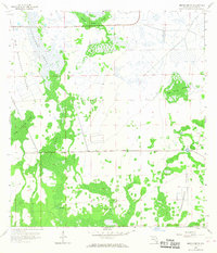
Big Corkscrew Island and Smallwood Island emerge as slightly elevated ground within the vast, water-logged expanse of the western Everglades during the late 1950s. This survey, compiled from aerial photography and planetable fieldwork, documents a landscape dominated by complex drainage patterns and seasonal wetlands. Distinctive corridors of cypress growth are identified as strands, including Baucom Cypress Strand and Rice Straw Strand, while the denser Corkscrew Swamp and Shaggy Cypress Swamp cover significant portions of the terrain. Human activity is sparse but notable for its industrial character, with an Oil Well, a Quarry, and a Gravel Pit located on the eastern side of the quadrangle. These features, alongside isolated benchmarks like BM 22, indicate the early stages of resource extraction and infrastructure development in this corner of Collier County.
Find a feature on this map
16 named features on this map. Tap any name to fly to it.
Don’t see what you’re looking for? This feature index may not catch every label — zoom into the map to look around manually.
Map Details
Editions of this 1958 Immokalee SW Map
4 editions found
Historical Maps of Ave Maria Through Time
221 maps found

1958 Belle Meade
Collier County, FL

1958 Belle Meade NE
Collier County, FL

1958 Belle Meade NW
Collier County, FL

1958 Belle Meade SE
Collier County, FL

1958 Catherine Island
Collier County, FL

1958 Corkscrew
Collier County, FL

1958 Corkscrew SE
Collier County, FL

1958 Corkscrew SW
Collier County, FL

1958 Immokalee NE
Collier County, FL

1958 Immokalee SW
Collier County, FL

1958 Naples North
Collier County, FL

1958 Naples South
Collier County, FL

1958 Sunniland
Collier County, FL

1959 Deep Lake
Collier County, FL

1959 Deep Lake SW
Collier County, FL

1959 Miles City
Collier County, FL

1962 Catherine Island
Collier County, FL

1972 Burns Lake
Collier County, FL

1972 Monroe Station NE
Collier County, FL

1972 Ochopee
Collier County, FL

1972 Weavers Station
Collier County, FL

1973 Cape Romano
Collier County, FL

1973 Fiftymile Bend
Collier County, FL

1973 Gator Hook Swamp
Collier County, FL

1973 Monroe Station
Collier County, FL

1973 North Of Fiftymile Bend
Collier County, FL

1973 Royal Palm Hammock
Collier County, FL

1974 Airplane Prairie
Collier County, FL

1974 California Slough
Collier County, FL

1974 Everglades City
Collier County, FL

1974 Little Marsh
Collier County, FL

1974 Panther Key
Collier County, FL

1974 Thompson Pine Island
Collier County, FL

1974 West Of Horseshoe Head
Collier County, FL

1974 Whidden Lake
Collier County, FL

1982 Everglades City
Collier County, FL

1995 Fiftymile Bend
Collier County, FL

1995 Monroe Station
Collier County, FL

1995 North Of Fiftymile Bend
Collier County, FL

2012 Airplane Prairie
Collier County, FL

2012 Belle Meade
Collier County, FL

2012 Belle Meade NE
Collier County, FL

2012 Belle Meade NW
Collier County, FL

2012 Belle Meade SE
Collier County, FL

2012 Burns Lake
Collier County, FL

2012 California Slough
Collier County, FL

2012 Cape Romano
Collier County, FL

2012 Catherine Island
Collier County, FL

2012 Corkscrew
Collier County, FL

2012 Corkscrew SE
Collier County, FL

2012 Corkscrew SW
Collier County, FL

2012 Deep Lake
Collier County, FL

2012 Deep Lake SW
Collier County, FL

2012 Everglades City
Collier County, FL

2012 Fiftymile Bend
Collier County, FL

2012 Gator Hook Swamp
Collier County, FL

2012 Immokalee NE
Collier County, FL

2012 Immokalee SW
Collier County, FL

2012 Little Marsh
Collier County, FL

2012 Marco Island OE W
Collier County, FL

2012 Miles City
Collier County, FL

2012 Monroe Station
Collier County, FL

2012 Monroe Station NE
Collier County, FL

2012 Naples North
Collier County, FL

2012 Naples South
Collier County, FL

2012 North of Fiftymile Bend
Collier County, FL

2012 Ochopee
Collier County, FL

2012 Panther Key
Collier County, FL

2012 Royal Palm Hammock
Collier County, FL

2012 Sunniland
Collier County, FL

2012 Thompson Pine Island
Collier County, FL

2012 Weavers Station
Collier County, FL

2012 West of Horseshoe Head
Collier County, FL

2012 Whidden Lake
Collier County, FL

2015 Airplane Prairie
Collier County, FL

2015 Belle Meade
Collier County, FL

2015 Belle Meade NE
Collier County, FL

2015 Belle Meade NW
Collier County, FL

2015 Belle Meade SE
Collier County, FL

2015 Burns Lake
Collier County, FL

2015 California Slough
Collier County, FL

2015 Cape Romano
Collier County, FL

2015 Catherine Island
Collier County, FL

2015 Corkscrew
Collier County, FL

2015 Corkscrew SE
Collier County, FL

2015 Corkscrew SW
Collier County, FL

2015 Deep Lake
Collier County, FL

2015 Deep Lake SW
Collier County, FL

2015 Everglades City
Collier County, FL

2015 Fiftymile Bend
Collier County, FL

2015 Gator Hook Swamp
Collier County, FL

2015 Immokalee NE
Collier County, FL

2015 Immokalee SW
Collier County, FL

2015 Little Marsh
Collier County, FL

2015 Marco Island OE W
Collier County, FL

2015 Miles City
Collier County, FL

2015 Monroe Station
Collier County, FL

2015 Monroe Station NE
Collier County, FL

2015 Naples North
Collier County, FL

2015 Naples South
Collier County, FL

2015 North of Fiftymile Bend
Collier County, FL

2015 Ochopee
Collier County, FL

2015 Panther Key
Collier County, FL

2015 Royal Palm Hammock
Collier County, FL

2015 Sunniland
Collier County, FL

2015 Thompson Pine Island
Collier County, FL

2015 Weavers Station
Collier County, FL

2015 West of Horseshoe Head
Collier County, FL

2015 Whidden Lake
Collier County, FL

2018 Airplane Prairie
Collier County, FL

2018 Belle Meade
Collier County, FL

2018 Belle Meade NE
Collier County, FL

2018 Belle Meade NW
Collier County, FL

2018 Belle Meade SE
Collier County, FL

2018 Burns Lake
Collier County, FL

2018 California Slough
Collier County, FL

2018 Cape Romano
Collier County, FL

2018 Catherine Island
Collier County, FL

2018 Corkscrew
Collier County, FL

2018 Corkscrew SE
Collier County, FL

2018 Corkscrew SW
Collier County, FL

2018 Deep Lake
Collier County, FL

2018 Deep Lake SW
Collier County, FL

2018 Everglades City
Collier County, FL

2018 Fiftymile Bend
Collier County, FL

2018 Gator Hook Swamp
Collier County, FL

2018 Immokalee NE
Collier County, FL

2018 Immokalee SW
Collier County, FL

2018 Little Marsh
Collier County, FL

2018 Marco Island OE W
Collier County, FL

2018 Miles City
Collier County, FL

2018 Monroe Station
Collier County, FL

2018 Monroe Station NE
Collier County, FL

2018 Naples North
Collier County, FL

2018 Naples South
Collier County, FL

2018 North of Fiftymile Bend
Collier County, FL

2018 Ochopee
Collier County, FL

2018 Panther Key
Collier County, FL

2018 Royal Palm Hammock
Collier County, FL

2018 Sunniland
Collier County, FL

2018 Thompson Pine Island
Collier County, FL

2018 Weavers Station
Collier County, FL

2018 West of Horseshoe Head
Collier County, FL

2018 Whidden Lake
Collier County, FL

2021 Airplane Prairie
Collier County, FL

2021 Belle Meade
Collier County, FL

2021 Belle Meade NE
Collier County, FL

2021 Belle Meade NW
Collier County, FL

2021 Belle Meade SE
Collier County, FL

2021 Burns Lake
Collier County, FL

2021 California Slough
Collier County, FL

2021 Cape Romano
Collier County, FL

2021 Catherine Island
Collier County, FL

2021 Corkscrew
Collier County, FL

2021 Corkscrew SE
Collier County, FL

2021 Corkscrew SW
Collier County, FL

2021 Deep Lake
Collier County, FL

2021 Deep Lake SW
Collier County, FL

2021 Everglades City
Collier County, FL

2021 Fiftymile Bend
Collier County, FL

2021 Gator Hook Swamp
Collier County, FL

2021 Immokalee NE
Collier County, FL

2021 Immokalee SW
Collier County, FL

2021 Little Marsh
Collier County, FL

2021 Marco Island OE W
Collier County, FL

2021 Miles City
Collier County, FL

2021 Monroe Station
Collier County, FL

2021 Monroe Station NE
Collier County, FL

2021 Naples North
Collier County, FL

2021 Naples South
Collier County, FL

2021 North of Fiftymile Bend
Collier County, FL

2021 Ochopee
Collier County, FL

2021 Panther Key
Collier County, FL

2021 Royal Palm Hammock
Collier County, FL

2021 Sunniland
Collier County, FL

2021 Thompson Pine Island
Collier County, FL

2021 Weavers Station
Collier County, FL

2021 West of Horseshoe Head
Collier County, FL

2021 Whidden Lake
Collier County, FL

2024 Airplane Prairie
Collier County, FL

2024 Belle Meade
Collier County, FL

2024 Belle Meade NE
Collier County, FL

2024 Belle Meade NW
Collier County, FL

2024 Belle Meade SE
Collier County, FL

2024 Burns Lake
Collier County, FL

2024 California Slough
Collier County, FL

2024 Cape Romano
Collier County, FL

2024 Catherine Island
Collier County, FL

2024 Corkscrew
Collier County, FL

2024 Corkscrew SE
Collier County, FL

2024 Corkscrew SW
Collier County, FL

2024 Deep Lake
Collier County, FL

2024 Deep Lake SW
Collier County, FL

2024 Everglades City
Collier County, FL

2024 Fiftymile Bend
Collier County, FL

2024 Gator Hook Swamp
Collier County, FL

2024 Immokalee NE
Collier County, FL

2024 Immokalee SW
Collier County, FL

2024 Little Marsh
Collier County, FL

2024 Marco Island OE W
Collier County, FL

2024 Miles City
Collier County, FL

2024 Monroe Station
Collier County, FL

2024 Monroe Station NE
Collier County, FL

2024 Naples North
Collier County, FL

2024 Naples South
Collier County, FL

2024 North of Fiftymile Bend
Collier County, FL

2024 Ochopee
Collier County, FL

2024 Panther Key
Collier County, FL

2024 Royal Palm Hammock
Collier County, FL

2024 Sunniland
Collier County, FL

2024 Thompson Pine Island
Collier County, FL

2024 Weavers Station
Collier County, FL

2024 West of Horseshoe Head
Collier County, FL

2024 Whidden Lake
Collier County, FL

2025 Cape Romano
Collier County, FL

2025 Everglades City
Collier County, FL

2025 Marco Island OE W
Collier County, FL

2025 Naples North
Collier County, FL

2025 Naples South
Collier County, FL

2025 Panther Key
Collier County, FL

2025 Royal Palm Hammock
Collier County, FL