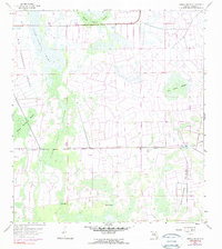
1958 Map of Immokalee SW
USGS Topo · Published 1990About this map
Big Corkscrew Swamp and the dense hydrological network of Southwest Florida dominate this 1958 survey, showing a landscape defined by seasonal strands and cypress wetlands. The terrain is characterized by longitudinal flow patterns like Keais Strand and Baucom Cypress Strand, which highlight the slow movement of water across this part of Collier County. These natural features are punctuated by elevated areas such as Smallwood Island, offering dry ground amidst the surrounding Shaggy Cypress Swamp.
Find a feature on this map
15 named features on this map. Tap any name to fly to it.
Don’t see what you’re looking for? This feature index may not catch every label — zoom into the map to look around manually.
Map Details
Editions of this 1958 Immokalee SW Map
4 editions found
Other maps of this area

1956 · West Palm Beach
USGS Topo · 1:250,000

1957 · West Palm Beach
USGS Topo · 1:250,000

1958 · West Palm Beach
USGS Topo · 1:250,000

1958 · Corkscrew SE
USGS Topo · 1:24,000

1958 · Catherine Island
USGS Topo · 1:24,000

1958 · Immokalee
USGS Topo · 1:24,000

1958 · Sunniland
USGS Topo · 1:24,000

1958 · Belle Meade NE
USGS Topo · 1:24,000

1958 · Immokalee NE
USGS Topo · 1:24,000

1958 · Immokalee SW
USGS Topo · 1:24,000