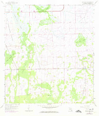
1958 Map of Immokalee SW
USGS Topo · Published 1974About this map
Big Corkscrew Island and Smallwood Island emerge as slightly elevated regions within the watery expanses of the western Everglades during the mid-twentieth century. This environment is defined by its complex drainage patterns, where slow-moving water corridors known as strands—including Baucom Cypress Strand, Keais Strand, and Rice Straw Strand—navigate through the larger Corkscrew Swamp. Human presence in this wet landscape is marked primarily by extraction and resource management, with an Oil Well, Quarry, and Gravel Pit located on the eastern margins. The map reflects a period before heavy modern development, showing the natural transition between the Shaggy Cypress Swamp and isolated water bodies like Cox Lake and Brown Lake. The purple revisions from 1973 indicate early changes in road infrastructure and drainage that would begin to alter these traditional wetlands.
Find a feature on this map
14 named features on this map. Tap any name to fly to it.
Don’t see what you’re looking for? This feature index may not catch every label — zoom into the map to look around manually.
Map Details
Editions of this 1958 Immokalee SW Map
4 editions found
Other maps of this area

1956 · West Palm Beach
USGS Topo · 1:250,000

1957 · West Palm Beach
USGS Topo · 1:250,000

1958 · West Palm Beach
USGS Topo · 1:250,000

1958 · Corkscrew SE
USGS Topo · 1:24,000

1958 · Catherine Island
USGS Topo · 1:24,000

1958 · Immokalee
USGS Topo · 1:24,000

1958 · Sunniland
USGS Topo · 1:24,000

1958 · Belle Meade NE
USGS Topo · 1:24,000

1958 · Immokalee NE
USGS Topo · 1:24,000

1958 · Immokalee SW
USGS Topo · 1:24,000