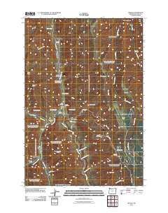
2011 Map of Imnaha
USGS Topo · Published 2011About this map
The Imnaha River and its confluence with Big Sheep Creek anchor this topographic view of eastern Oregon. In this remote valley, the small settlement of Imnaha serves as a vital point of interest, where local civic life is represented by The Bridge School, the Imnaha Post Office, and the nearby Imnaha Cemetery located at the base of Cemetery Hill. The landscape is a complex network of steep drainage systems, including Pumpkin Creek and Burcher Canyon, which feed into the primary river valley.
Find a feature on this map
48 named features on this map. Tap any name to fly to it.
Don’t see what you’re looking for? This feature index may not catch every label — zoom into the map to look around manually.
Map Details
Editions of this 2011 Imnaha Map
This is the sole edition of this map. No revisions or reprints were ever made.
Other maps of this area

1922 · He Devil
USGS Topo · 1:48,000

1954 · Imnaha
USGS Topo · 1:62,500

1954 · Kernan Point
USGS Topo · 1:62,500

1954 · Harl Butte
USGS Topo · 1:62,500

1955 · Grangeville
USGS Topo · 1:250,000

1957 · He Devil
USGS Topo · 1:62,500

1959 · Grangeville
USGS Topo · 1:250,000

1980 · Grangeville
USGS Topo · 1:100,000

1987 · Riggins
USGS Topo · 1:100,000

1990 · Imnaha
USGS Topo · 1:24,000