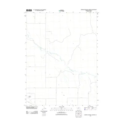
2011 Map of Imperial Municipal Airport
USGS Topo · Published 2011About this map
Spring Creek meanders southeastward across this high plains landscape in Chase County, providing a natural drainage pattern that breaks the geometric precision of the regional road grid. This agricultural sector of southwestern Nebraska is defined by a rigid section-line system of avenues and roads, including 335 Ave and 737 Rd. The landscape's primary modern hub is the Imperial Municipal Airport, located in the southwestern corner. The map reveals the relationship between the natural watercourse of the creek and the human-imposed boundary lines that define property and transit in this rural environment. Researchers can trace the path of numerous county routes like 744 Rd and 334 Ave as they navigate the subtle topography of the creek basin.
Find a feature on this map
15 named features on this map. Tap any name to fly to it.
Don’t see what you’re looking for? This feature index may not catch every label — zoom into the map to look around manually.
Map Details
Editions of this 2011 Imperial Municipal Airport Map
This is the sole edition of this map. No revisions or reprints were ever made.
Other maps of this area

1954 · McCook
USGS Topo · 1:250,000

1957 · McCook
USGS Topo · 1:250,000

1958 · McCook
USGS Topo · 1:250,000

1973 · Champion
USGS Topo · 1:24,000

1973 · Imperial NE
USGS Topo · 1:24,000

1973 · Enders
USGS Topo · 1:24,000

1973 · Imperial
USGS Topo · 1:24,000

1973 · Dittons Creek NW
USGS Topo · 1:24,000
1973 · Imperial NW
USGS Topo · 1:24,000

1973 · Imperial Municipal Airport
USGS Topo · 1:24,000