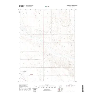
2017 Map of Imperial Municipal Airport
USGS Topo · Published 2017About this map
Imperial occupies the southwestern corner of this survey, representing the primary population center in this section of Chase County. The landscape is defined by the high plains of Southwest Nebraska, where the seasonal waters of Spring Cr carve subtle drainage patterns across the upland terrain. This 2017 edition illustrates the transition between the gridded agricultural fields and the infrastructure of the Imperial Municipal Airport, which sits just north of the town center.
Find a feature on this map
21 named features on this map. Tap any name to fly to it.
Don’t see what you’re looking for? This feature index may not catch every label — zoom into the map to look around manually.
Map Details
Editions of this 2017 Imperial Municipal Airport Map
This is the sole edition of this map. No revisions or reprints were ever made.
Other maps of this area

1954 · McCook
USGS Topo · 1:250,000

1957 · McCook
USGS Topo · 1:250,000

1958 · McCook
USGS Topo · 1:250,000

1973 · Champion
USGS Topo · 1:24,000

1973 · Imperial NE
USGS Topo · 1:24,000

1973 · Enders
USGS Topo · 1:24,000

1973 · Imperial
USGS Topo · 1:24,000

1973 · Dittons Creek NW
USGS Topo · 1:24,000
1973 · Imperial NW
USGS Topo · 1:24,000

1973 · Imperial Municipal Airport
USGS Topo · 1:24,000