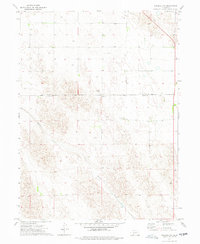
1973 Map of Imperial NW
USGS Topo · Published 1977About this map
Spring Creek meanders through the heart of this landscape, marking the topography of the Nebraska sandhills in the early 1970s. The survey covers the boundary between Perkins Co and Chase Co, capturing a rural area defined by agricultural development and resource extraction. Numerous wells are scattered throughout the sections, reflecting the importance of water management in this High Plains environment. Small-scale industrial activity is evident through the presence of several Gravel Pits, likely serving local road construction and maintenance needs during this era. The map also includes fine-grained details from the period's aerial surveys, such as field lines and fence boundaries, providing a clear view of land division and land-use patterns before modern consolidation.
Find a feature on this map
5 named features on this map. Tap any name to fly to it.
Don’t see what you’re looking for? This feature index may not catch every label — zoom into the map to look around manually.
Map Details
Editions of this 1973 Imperial NW Map
This is the sole edition of this map. No revisions or reprints were ever made.
Other maps of this area

1954 · McCook
USGS Topo · 1:250,000

1957 · McCook
USGS Topo · 1:250,000

1958 · McCook
USGS Topo · 1:250,000

1961 · Lamar NE
USGS Topo · 1:24,000

1961 · Brandon SE
USGS Topo · 1:24,000
1973 · Chase
USGS Topo · 1:24,000

1973 · Imperial NE
USGS Topo · 1:24,000

1973 · Imperial
USGS Topo · 1:24,000
1973 · Grant
USGS Topo · 1:24,000

1973 · Imperial Municipal Airport
USGS Topo · 1:24,000