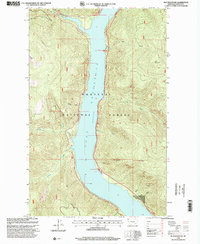
1997 Map of Inch Mountain
USGS Topo · Published 2000About this map
Koocanusa Lake dominates this section of the Kootenai National Forest, its long blue ribbon filling the canyon floor between steep timbered ridges. Revised by the Forest Service in the late 1990s, the map reveals a landscape defined by water management and high-country drainages. The reservoir was created after the completion of Libby Dam, submerging the former river valley and transforming the local geography into a series of inlets and points named for the old gulches that remain above the waterline.
Find a feature on this map
20 named features on this map. Tap any name to fly to it.
Don’t see what you’re looking for? This feature index may not catch every label — zoom into the map to look around manually.
Map Details
Editions of this 1997 Inch Mountain Map
This is the sole edition of this map. No revisions or reprints were ever made.
Other maps of this area

1957 · Kalispell
USGS Topo · 1:250,000

1960 · Kalispell
USGS Topo · 1:250,000

1961 · Kalispell
USGS Topo · 1:250,000

1963 · Mc Guire Mountain
USGS Topo · 1:24,000

1963 · Banfield Mountain
USGS Topo · 1:24,000

1963 · Webb Mountain
USGS Topo · 1:24,000

1963 · Boulder Lakes
USGS Topo · 1:24,000
1963 · Volcour
USGS Topo · 1:24,000
1963 · Inch Mountain
USGS Topo · 1:24,000
1963 · Beartrap Mountain
USGS Topo · 1:24,000