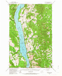
1950 Map of Inchelium
USGS Topo · Published 1963About this map
Franklin D Roosevelt Lake dominates the central corridor of this 1950s study, representing the impounded waters of the Columbia River following the completion of the Grand Coulee Dam. The map documents the eastern edge of the Colville Indian Reservation, marked by the Indian Reservation Boundary and the Colville Indian Subagency. The terrain rises sharply from the water toward the Huckleberry Mountains, where resource extraction is evident at the Columbia Tungsten Mine and Silver Summit Mine.
Find a feature on this map
90 named features on this map. Tap any name to fly to it.
Don’t see what you’re looking for? This feature index may not catch every label — zoom into the map to look around manually.
Map Details
Editions of this 1950 Inchelium Map
4 editions found

Other maps of this area

1927 · Chewelah
USGS Topo · 1:125,000

1929 · Colville
USGS Topo · 1:125,000

1930 · Chewelah
USGS Topo · 1:125,000

1933 · Colville
USGS Topo · 1:125,000

1936 · Marcus
USGS Topo · 1:96,000

1942 · Marcus
USGS Topo · 1:125,000

1948 · Sherman Peak
USGS Topo · 1:62,500

1948 · Kettle Falls
USGS Topo · 1:62,500

1948 · Hunters
USGS Topo · 1:62,500

1948 · Wilmont Creek
USGS Topo · 1:62,500