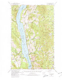
1950 Map of Inchelium
USGS Topo · Published 1980About this map
Franklin D Roosevelt Lake dominates this mid-century landscape, following the inundation caused by the Grand Coulee Dam. The Columbia River separates the Colville Indian Reservation to the west from the Colville National Forest and the Huckleberry Range to the east. Along the western shore, the Colville Indian Subagency and the town of Inchelium serve as the primary hubs, while the eastern side is defined by small settlements like Gifford, Rice, and Daisy.
Find a feature on this map
93 named features on this map. Tap any name to fly to it.
Don’t see what you’re looking for? This feature index may not catch every label — zoom into the map to look around manually.
Map Details
Editions of this 1950 Inchelium Map
4 editions found

Other maps of this area

1927 · Chewelah
USGS Topo · 1:125,000

1929 · Colville
USGS Topo · 1:125,000

1930 · Chewelah
USGS Topo · 1:125,000

1933 · Colville
USGS Topo · 1:125,000

1936 · Marcus
USGS Topo · 1:96,000

1942 · Marcus
USGS Topo · 1:125,000

1948 · Sherman Peak
USGS Topo · 1:62,500

1948 · Kettle Falls
USGS Topo · 1:62,500

1948 · Hunters
USGS Topo · 1:62,500

1948 · Wilmont Creek
USGS Topo · 1:62,500