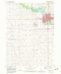
1973 Map of Independence
USGS Topo · Published 1983About this map
The Wapsipinicon River winds through this Buchanan County landscape, anchored by the significant developed area of Independence. In this early 1970s record, the town center is densely mapped with essential civic structures including the Courthouse, City Hall, and several educational facilities like St Johns High School and Jefferson School. A prominent landmark south of the main settlement is the Independence State Hospital, which maintains its own State Hospital Cemetery.
Find a feature on this map
40 named features on this map. Tap any name to fly to it.
Don’t see what you’re looking for? This feature index may not catch every label — zoom into the map to look around manually.
Map Details
Editions of this 1973 Independence Map
2 editions found
Other maps of this area

1901 · Oelwein
USGS Topo · 1:125,000

1903 · Winthrop
USGS Topo · 1:125,000

1954 · Waterloo
USGS Topo · 1:250,000

1955 · Waterloo
USGS Topo · 1:250,000

1959 · Dubuque
USGS Topo · 1:250,000

1961 · Dubuque
USGS Topo · 1:250,000

1962 · Dubuque
USGS Topo · 1:250,000
1971 · Brandon
USGS Topo · 1:24,000

1971 · Littleton
USGS Topo · 1:24,000
1971 · Jesup
USGS Topo · 1:24,000