
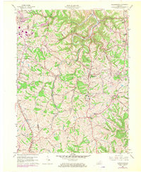
1961 Map of Independence
USGS Topo · Published 1962About this map
The rolling landscape of Kenton and Boone counties reveals a period of transition as post-war suburban growth begins to follow the established rail and road corridors of Northern Kentucky. The city of Independence serves as a central hub, surrounded by a network of smaller communities like White Tower, Nicholson (BM 930), and Bank Lick. The influence of transportation is evident in the paths of the Southern and Louisville and Nashville railroads, which parallel major thoroughfares such as Richardson Road and Decoursey Road.
Find a feature on this map
63 named features on this map. Tap any name to fly to it.
Don’t see what you’re looking for? This feature index may not catch every label — zoom into the map to look around manually.
Map Details
Editions of this 1961 Independence Map
2 editions found
Other maps of this area

1898 · East Cincinnati
USGS Topo · 1:62,500

1914 · East Cincinnati
USGS Topo · 1:62,500

1914 · West Cincinnati
USGS Topo · 1:62,500

1929 · Alexandria
USGS Topo · 1:48,000

1936 · Alexandria
USGS Topo · 1:62,500

1950 · Union
USGS Topo · 1:24,000

1950 · Independence
USGS Topo · 1:24,000

1950 · Verona
USGS Topo · 1:24,000

1950 · Walton
USGS Topo · 1:24,000

1950 · Covington
USGS Topo · 1:24,000