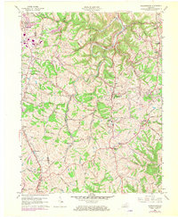
1961 Map of Independence
USGS Topo · Published 1970About this map
Independence serves as a central hub in this Kenton County landscape, situated amid a complex network of ridges and winding creek valleys. The settlement pattern is defined by traditional community anchors like St Cecilias Ch and the Independence Cem, while suburban expansion is visible in the development of Latonia Lakes and Oak Ridge. Two major rail lines, the Southern and the Louisville and Nashville, cut through the terrain, illustrating the region's historical reliance on rail transport for connecting the rural interior to the Ohio River valley. Evidence of local education and civil life is prominent through features like Kentontown High Sch and the Athletic Field. Natural drainage is dominated by the meandering Banklick Creek and Bullock Pen Creek, which have carved deep valleys that dictate the placement of winding routes like Richardson Road and Station Road.
Find a feature on this map
57 named features on this map. Tap any name to fly to it.
Don’t see what you’re looking for? This feature index may not catch every label — zoom into the map to look around manually.
Map Details
Editions of this 1961 Independence Map
2 editions found

Other maps of this area

1898 · East Cincinnati
USGS Topo · 1:62,500

1914 · East Cincinnati
USGS Topo · 1:62,500

1914 · West Cincinnati
USGS Topo · 1:62,500

1929 · Alexandria
USGS Topo · 1:48,000

1936 · Alexandria
USGS Topo · 1:62,500

1950 · Union
USGS Topo · 1:24,000

1950 · Independence
USGS Topo · 1:24,000

1950 · Verona
USGS Topo · 1:24,000

1950 · Walton
USGS Topo · 1:24,000

1950 · Covington
USGS Topo · 1:24,000