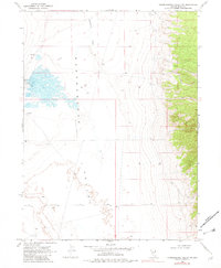
1968 Map of Independence Valley NW
USGS Topo · Published 1982About this map
Independence Valley dominates this high-desert basin in Elko County, Nevada, as it appeared in the late 1960s. The landscape is defined by its arid hydrology, featuring Independence Creek and several isolated water sources simply marked as Spring, Springs, and Well. Human activity is concentrated around Warm Springs Ranch on the western edge of the valley floor, where a nearby Borrow Pit indicates local land-use and small-scale excavation. The terrain transitions sharply from the level basin floor to the steep eastern mountain slopes, punctuated by a rugged Jeep Trail that provides the only significant inland access across the topographic contours. This survey reflects the sparse settlement patterns of the Great Basin, where life and transit were dictated by the location of scattered water points and the flat topography of the central depression.
Find a feature on this map
8 named features on this map. Tap any name to fly to it.
Don’t see what you’re looking for? This feature index may not catch every label — zoom into the map to look around manually.
Map Details
Editions of this 1968 Independence Valley NW Map
2 editions found
Other maps of this area

1955 · Wells
USGS Topo · 1:250,000

1955 · Elko
USGS Topo · 1:250,000

1958 · Wells
USGS Topo · 1:250,000

1958 · Elko
USGS Topo · 1:250,000

1961 · Wells
USGS Topo · 1:250,000

1962 · Elko
USGS Topo · 1:250,000

1965 · Elko
USGS Topo · 1:250,000

1968 · Moor Summit
USGS Topo · 1:24,000

1968 · Independence Valley NE
USGS Topo · 1:24,000

1968 · Independence Valley SW
USGS Topo · 1:24,000