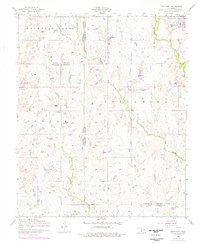
1956 Map of Indiahoma
USGS Topo · Published 1976About this map
Indiahoma sits as the primary settlement in this southwestern Oklahoma landscape, positioned at the intersection of three county lines. The town’s local social geography is anchored by the Indiahoma IOOF Cemetery and the Post Oak Mission School to its north. The surrounding plains are defined by a complex network of waterways, including Little Sandy Creek, Oak Creek, and Post Oak Creek, which drain the varied terrain of Mountain Park, Hunter, and Holton. Scattered across these farmsteads are several rural community centers, such as Prairie View Church and North Deep Red Church, indicating a dispersed but established agricultural population in the mid-1950s. The map illustrates how county boundaries for Comanche, Kiowa, and Tillman counties converge in this area, influencing local jurisdiction and land divisions. Genealogists may find value in the presence of Scofield Cemetery and numerous churches like the Pilgrim Church and Congregational Church that served the outlying families.
Find a feature on this map
22 named features on this map. Tap any name to fly to it.
Don’t see what you’re looking for? This feature index may not catch every label — zoom into the map to look around manually.
Map Details
Editions of this 1956 Indiahoma Map
2 editions found

Other maps of this area

1937 · Cache
USGS Topo · 1:48,000

1937 · Quanah Mountain
USGS Topo · 1:24,000

1942 · Cache
USGS Topo · 1:62,500

1949 · Quanah Mountain
USGS Topo · 1:24,000

1950 · Snyder
USGS Topo · 1:62,500

1955 · Lawton
USGS Topo · 1:250,000

1956 · Post Oak Creek
USGS Topo · 1:24,000

1956 · Odetta
USGS Topo · 1:24,000
1956 · Quanah Mountain
USGS Topo · 1:24,000

1956 · Manitou
USGS Topo · 1:24,000