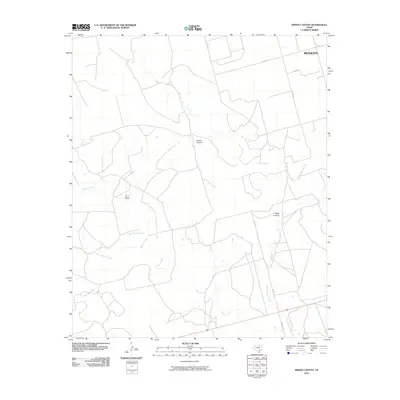
2010 Map of Indian Canyon
USGS Topo · Published 2010About this map
Mesquite occupies the northeastern corner of this landscape, marking a small settlement point amid a complex network of dry draws and seasonal waterways. The drainage patterns of the Llano Estacado edge are clearly defined by the paths of Tobacco Creek and Wet Tobacco Creek as they wind through the central portion of the quadrangle. These watercourses create significant topographical relief, most notably at the namesake Indian Canyon and the neighboring Buck Canyon to the east. The map details a grid of rural transportation routes, including Co RD 133 and the curiously named Outlaw Rd, which serve the agricultural and ranching parcels of the region. The intermittent nature of the hydrology, from Buck Canyon Creek to the T J F Draw, reflects the arid character of the Borden County environment at the time of this 2010 survey.
Find a feature on this map
13 named features on this map. Tap any name to fly to it.
Don’t see what you’re looking for? This feature index may not catch every label — zoom into the map to look around manually.
Map Details
Editions of this 2010 Indian Canyon Map
This is the sole edition of this map. No revisions or reprints were ever made.
Other maps of this area

1954 · Big Spring
USGS Topo · 1:250,000

1958 · Big Spring
USGS Topo · 1:250,000

1968 · Hancock
USGS Topo · 1:24,000

1969 · O'Donnell
USGS Topo · 1:24,000

1969 · Indian Canyon NE
USGS Topo · 1:24,000

1969 · Indian Canyon
USGS Topo · 1:24,000

1969 · Holloway Canyon
USGS Topo · 1:24,000
1970 · Indian Canyon NW
USGS Topo · 1:24,000

1970 · Key
USGS Topo · 1:24,000

1970 · Sand Creek
USGS Topo · 1:24,000