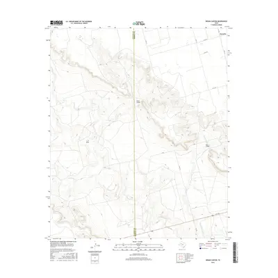
2016 Map of Indian Canyon
USGS Topo · Published 2016About this map
Indian Canyon and Buck Canyon dominate this West Texas landscape, cutting deep relief across the boundary between Dawson County and Borden County. The area is characterized by an intricate drainage system including Tobacco Cr, Wet Tobacco Cr, and Buck Canyon Cr, which collectively feed the regional watershed. This 2016 survey illustrates the intersection of traditional West Texas ranching geography with modern infrastructure, as shown by the network of county roads like Co RD 133 and Co RD 125 that grid the plateau above the canyons. In the northeast corner, the settlement of Mesquite sits near the headwaters of the canyon system, while T J F Draw provides a prominent topographical landmark to the southwest. The presence of FM 1054 in the southeast provides a primary transport link through this remote section of the High Plains.
Find a feature on this map
15 named features on this map. Tap any name to fly to it.
Don’t see what you’re looking for? This feature index may not catch every label — zoom into the map to look around manually.
Map Details
Editions of this 2016 Indian Canyon Map
This is the sole edition of this map. No revisions or reprints were ever made.
Other maps of this area

1954 · Big Spring
USGS Topo · 1:250,000

1958 · Big Spring
USGS Topo · 1:250,000

1968 · Hancock
USGS Topo · 1:24,000

1969 · O'Donnell
USGS Topo · 1:24,000

1969 · Indian Canyon NE
USGS Topo · 1:24,000

1969 · Indian Canyon
USGS Topo · 1:24,000

1969 · Holloway Canyon
USGS Topo · 1:24,000
1970 · Indian Canyon NW
USGS Topo · 1:24,000

1970 · Key
USGS Topo · 1:24,000

1970 · Sand Creek
USGS Topo · 1:24,000