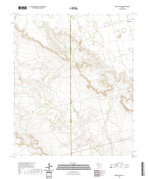
2022 Map of Indian Canyon
USGS Topo · Published 2022About this map
Indian Canyon carves a complex drainage network across this High Plains landscape, where the Dawson Co Borden Co line divides the terrain. This rural expanse is defined by the winding paths of Tobacco Cr and Wet Tobacco Cr, which illustrate the seasonal hydrology of the region. The settlement of Mesquite stands in the northeast corner, serving as a landmark in a territory otherwise dominated by cattle ranching and occasional agricultural plots. Transport across the plains is facilitated by a network of county roads like Co RD 133 and Co RD 131, while Fm 1054 cuts through the southern reaches. The intricate contour lines of Buck Canyon and the T J F Draw reveal the erosive power of water on the Texas caprock, providing a clear view of the distinct breaks and draws that characterize this part of the state.
Find a feature on this map
21 named features on this map. Tap any name to fly to it.
Don’t see what you’re looking for? This feature index may not catch every label — zoom into the map to look around manually.
Map Details
Editions of this 2022 Indian Canyon Map
This is the sole edition of this map. No revisions or reprints were ever made.
Other maps of this area

1954 · Big Spring
USGS Topo · 1:250,000

1958 · Big Spring
USGS Topo · 1:250,000

1968 · Hancock
USGS Topo · 1:24,000

1969 · O'Donnell
USGS Topo · 1:24,000

1969 · Indian Canyon NE
USGS Topo · 1:24,000

1969 · Indian Canyon
USGS Topo · 1:24,000

1969 · Holloway Canyon
USGS Topo · 1:24,000
1970 · Indian Canyon NW
USGS Topo · 1:24,000

1970 · Key
USGS Topo · 1:24,000

1970 · Sand Creek
USGS Topo · 1:24,000