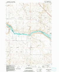
1992 Map of Indian Cove
USGS Topo · Published 1992About this map
The Snake River carves through this high desert landscape, defining the boundary between Elmore and Owyhee counties. The waterway is a hub of utility and preservation, featuring the C J Strike Wildlife Management Area to the west and the expansive Birds of Prey Area spanning the river banks. Civil engineering of the late 20th century is evident in the network of pumping stations, an aqueduct, and a siphon that manage water across the arid terrain.
Find a feature on this map
41 named features on this map. Tap any name to fly to it.
Don’t see what you’re looking for? This feature index may not catch every label — zoom into the map to look around manually.
Map Details
Editions of this 1992 Indian Cove Map
This is the sole edition of this map. No revisions or reprints were ever made.
Other maps of this area

1892 · Mountain Home
USGS Topo · 1:125,000

1892 · Camas Prairie
USGS Topo · 1:125,000

1893 · Mountain Home
USGS Topo · 1:125,000

1893 · Camas Prairie
USGS Topo · 1:125,000

1947 · Indian Cove
USGS Topo · 1:24,000

1947 · Hammett
USGS Topo · 1:24,000

1947 · Sand Dunes
USGS Topo · 1:24,000

1947 · Hot Spring
USGS Topo · 1:24,000

1948 · Sand Dunes
USGS Topo · 1:24,000

1948 · Hammett
USGS Topo · 1:24,000