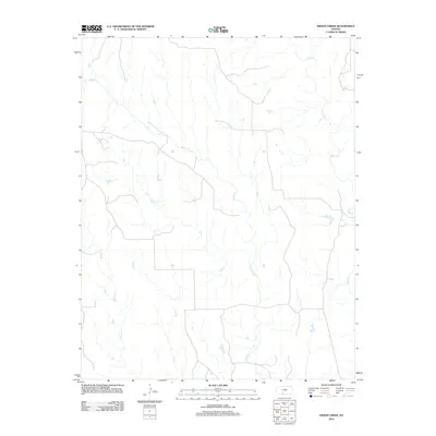
2012 Map of Indian Creek
USGS Topo · Published 2012About this map
Indian Cr and Mule Cr define the hydrological landscape of this southern Kansas region, where a network of seasonal streams branches across the open terrain. This 2012 survey shows a sparsely populated area in Comanche County dominated by natural watercourses rather than dense human settlement. Tributaries like Owl Cr, Wildcat Cr, and Dog Cr carve through the landscape, illustrating the drainage patterns that have shaped the ranching and agricultural potential of the region for generations. The map reveals the intricate dendritic structure of these creeks, which provide the primary geographical orientation in a landscape defined by its subtle topographic shifts and expansive rural character.
Find a feature on this map
5 named features on this map. Tap any name to fly to it.
Don’t see what you’re looking for? This feature index may not catch every label — zoom into the map to look around manually.
Map Details
Editions of this 2012 Indian Creek Map
This is the sole edition of this map. No revisions or reprints were ever made.
Other maps of this area

1891 · Medicine Lodge
USGS Topo · 1:125,000

1892 · Coldwater
USGS Topo · 1:125,000

1893 · Medicine Lodge
USGS Topo · 1:125,000

1955 · Pratt
USGS Topo · 1:250,000

1959 · Pratt
USGS Topo · 1:250,000

1968 · Sun City SW
USGS Topo · 1:24,000

1968 · Wilmore SE
USGS Topo · 1:24,000
1973 · Deerhead
USGS Topo · 1:24,000
1973 · Aetna
USGS Topo · 1:24,000
1979 · Nescatunga Creek South
USGS Topo · 1:24,000