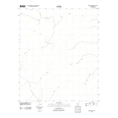
2010 Map of Indian Draw
USGS Topo · Published 2010About this map
Indian Draw and a network of ephemeral watercourses define this arid landscape in southeastern New Mexico during the early twenty-first century. The area is characterized by a sparse infrastructure of ranch roads, such as County RD-E001 and County RD-E008, which connect isolated water catchment systems essential for livestock and local land management. These man-made features, including Munson Tank, Merrit Tank, and McLane Tank, are strategically placed among the natural drainages of Moccasin Draw and Rough Draw. This topography illustrates the vital relationship between water management and survival in the Chihuahuan Desert environment, showing how family-named landmarks like George Tank and Otto Tank serve as critical points of reference in an otherwise open and undeveloped expanse of Otero County.
Find a feature on this map
19 named features on this map. Tap any name to fly to it.
Don’t see what you’re looking for? This feature index may not catch every label — zoom into the map to look around manually.
Map Details
Editions of this 2010 Indian Draw Map
This is the sole edition of this map. No revisions or reprints were ever made.
Other maps of this area

1954 · Carlsbad
USGS Topo · 1:250,000

1958 · Carlsbad
USGS Topo · 1:250,000

1963 · Cornucopia Canyon
USGS Topo · 1:24,000
1963 · Cornucopia Ranch SE
USGS Topo · 1:24,000

1963 · Indian Draw
USGS Topo · 1:24,000

1963 · Cleones Tank
USGS Topo · 1:24,000

1965 · Surveyors Canyon
USGS Topo · 1:24,000

1965 · Pinon
USGS Topo · 1:24,000
1965 · Cornucopia Canyon
USGS Topo · 1:24,000

1979 · Alamogordo
USGS Topo · 1:100,000