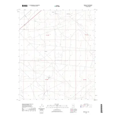
2020 Map of Indian Flats
USGS Topo · Published 2020About this map
Indian Flats and the surrounding high desert of Eddy County are defined by subtle topographic shifts and essential transport routes. The seasonal watercourse of Old Indian Draw cuts through the southern portion of the quadrangle, while prominent terrain features like Sand Point and the elevations of Quahada Ridge provide orientation in an otherwise expansive landscape. The modern infrastructure of the region is traced through a network of local thoroughfares, including Landfill Rd and several numbered county routes. This survey highlights the spatial organization of the area under the Public Land Survey System, showing the township and range divisions of T21S R28E and its neighbors. The road network, featuring Co Rd 603 and Magnum Rd, suggests an active industrial or ranching presence integrated into the arid New Mexico environment.
Find a feature on this map
13 named features on this map. Tap any name to fly to it.
Don’t see what you’re looking for? This feature index may not catch every label — zoom into the map to look around manually.
Map Details
Editions of this 2020 Indian Flats Map
This is the sole edition of this map. No revisions or reprints were ever made.
Other maps of this area

1939 · Carlsbad
USGS Topo · 1:62,500

1939 · Nash Draw
USGS Topo · 1:62,500

1942 · Clayton Basin
USGS Topo · 1:62,500

1943 · Carlsbad
USGS Topo · 1:62,500

1943 · Clayton Basin
USGS Topo · 1:62,500

1943 · Oil City
USGS Topo · 1:62,500

1943 · Nash Draw
USGS Topo · 1:62,500

1954 · Carlsbad
USGS Topo · 1:250,000

1954 · Hobbs
USGS Topo · 1:250,000

1958 · Carlsbad
USGS Topo · 1:250,000