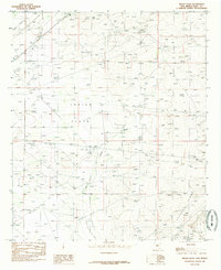
1985 Map of Indian Flats
USGS Topo · Published 1985About this map
Indian Flats dominates this mid-1980s landscape in Eddy County, where the desert terrain is defined by dry watercourses and industrial infrastructure. The map illustrates a transitional environment where natural features like Sand Point and the elevations of Quahada Ridge meet late-century resource extraction and water management. Of particular interest to local historians is the Abandoned Canal winding through the western portion, a relic of earlier irrigation efforts in this arid region. The presence of a Pumping Sta, an Aqueduct, and several Gravel Pits reflects the area's development around utility and construction materials. Seasonal drainage patterns are clearly marked by Fenton Draw and Old Indian Draw, providing insight into the hydraulic history and land use of this section of the New Mexico desert.
Find a feature on this map
11 named features on this map. Tap any name to fly to it.
Don’t see what you’re looking for? This feature index may not catch every label — zoom into the map to look around manually.
Map Details
Editions of this 1985 Indian Flats Map
This is the sole edition of this map. No revisions or reprints were ever made.
Other maps of this area

1939 · Carlsbad
USGS Topo · 1:62,500

1939 · Nash Draw
USGS Topo · 1:62,500

1942 · Clayton Basin
USGS Topo · 1:62,500

1943 · Carlsbad
USGS Topo · 1:62,500

1943 · Clayton Basin
USGS Topo · 1:62,500

1943 · Oil City
USGS Topo · 1:62,500

1943 · Nash Draw
USGS Topo · 1:62,500

1954 · Carlsbad
USGS Topo · 1:250,000

1954 · Hobbs
USGS Topo · 1:250,000

1958 · Carlsbad
USGS Topo · 1:250,000