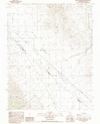
1987 Map of Indian Garden Creek
USGS Topo · Published 1987About this map
Fish Lake Valley straddles the high desert borderlands where the Esmeralda and Mono County line meets the state boundary between Nevada and California. This 1987 provisional survey documents a landscape defined by drainage systems and mineral exploration, featuring the Von Schmidt Line (1873) which traces the historic geopolitical boundary across the arid floor. Mining activity is evident in the northern reaches, particularly at the Good Hope Mine and Lookout Mine, along with numerous unnamed prospects. To the south, Indian Garden Creek provides a notable water source, while the eastern terrain is carved by the White Wolf Canyon and its corresponding White Wolf Wash. The map reflects a period of modern topographic revision based on mid-century aerial photography, preserving the locations of remote claims and the path of the original 19th-century state line survey.
Find a feature on this map
11 named features on this map. Tap any name to fly to it.
Don’t see what you’re looking for? This feature index may not catch every label — zoom into the map to look around manually.
Map Details
Editions of this 1987 Indian Garden Creek Map
This is the sole edition of this map. No revisions or reprints were ever made.
Other maps of this area

1898 · Silver Peak
USGS Topo · 1:125,000

1900 · Silver Peak
USGS Topo · 1:125,000

1908 · Lida
USGS Topo · 1:250,000

1913 · Bishop
USGS Topo · 1:125,000

1913 · Lida
USGS Topo · 1:250,000

1917 · White Mountain
USGS Topo · 1:125,000

1947 · Mariposa
USGS Topo · 1:250,000

1948 · Mariposa
USGS Topo · 1:250,000

1951 · Blanco Mountain
USGS Topo · 1:62,500

1954 · Goldfield
USGS Topo · 1:250,000