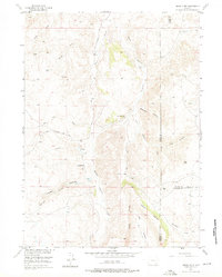
1955 Map of Indian Guide
USGS Topo · Published 1976About this map
The South Sybille Sch stands as a landmark of mid-century rural education in this high-altitude Wyoming landscape, where the confluence of three counties—Albany, Platte, and Laramie—creates a complex topographical boundary. This 1955 survey documents a rugged ranching corridor defined by the drainage of South Sybille Creek and its many tributaries, including Bar Two Creek and Canteen Creek. The presence of the Shaffer Sch and the winding Old Wheatland Road reflects the traditional movement patterns of the era, connecting isolated homesteads through narrow canyons and over prominent heights like Iron Mountain. The map reveals a transition from open range to more structured transit as it follows Indian Guide Creek through the winding Indian Guide Hay Canyon, providing a detailed record of the water sources and early roads that supported life in this tri-county border region.
Find a feature on this map
21 named features on this map. Tap any name to fly to it.
Don’t see what you’re looking for? This feature index may not catch every label — zoom into the map to look around manually.
Map Details
Editions of this 1955 Indian Guide Map
3 editions found
Other maps of this area

1953 · Natwick SW
USGS Topo · 1:24,000

1954 · Cheyenne
USGS Topo · 1:250,000

1955 · Poe Mountain
USGS Topo · 1:24,000

1955 · Indian Guide
USGS Topo · 1:24,000

1955 · Guide Rock
USGS Topo · 1:24,000

1955 · Baldy Mountain
USGS Topo · 1:24,000

1955 · Sheep Rock
USGS Topo · 1:24,000

1955 · Goat Mountain
USGS Topo · 1:24,000

1958 · Cheyenne
USGS Topo · 1:250,000

1962 · Farthing
USGS Topo · 1:24,000