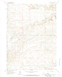
1963 Map of Indian Hill
USGS Topo · Published 1967About this map
Indian Hill stands as a prominent landmark in this high plains landscape along the border of Laramie and Goshen counties. The terrain is defined by the winding paths of Bear Creek and Little Bear Creek, which cut through the undulating plateaus. Settlement in the early 1960s was sparse, centered on working agricultural operations like the Double Lazy T Ranch and the presence of the JHD Sch in the southern portion of the quadrangle. Irrigation infrastructure is represented by the Garden Ditch, tracing the contours near the northern boundary. The road network is limited to unpaved routes such as Indian Hill Road, reflecting the rural, ranch-oriented character of this Wyoming region before modern development. Notable geodetic markers like Model provide a glimpse into the precise surveying efforts required to map this cattle-country topography.
Find a feature on this map
12 named features on this map. Tap any name to fly to it.
Don’t see what you’re looking for? This feature index may not catch every label — zoom into the map to look around manually.
Map Details
Editions of this 1963 Indian Hill Map
2 editions found
Other maps of this area

1911 · Cheyenne
USGS Topo · 1:125,000

1914 · Cheyenne
USGS Topo · 1:125,000

1954 · Cheyenne
USGS Topo · 1:250,000

1958 · Cheyenne
USGS Topo · 1:250,000

1962 · Moffett Ranch
USGS Topo · 1:24,000

1962 · Lewis Ranch
USGS Topo · 1:24,000

1962 · Bristol Ridge NE
USGS Topo · 1:24,000

1963 · Little Indian Draw
USGS Topo · 1:24,000

1963 · C S Ranch
USGS Topo · 1:24,000
1963 · Cattail Ranch
USGS Topo · 1:24,000