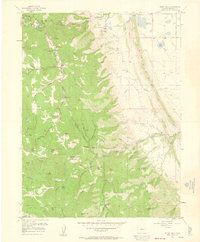
1957 Map of Indian Hills
USGS Topo · Published 1960About this map
Indian Hills and the winding descent of Turkey Creek Canyon define this high-altitude landscape in the mid-1950s. The settlement pattern is dominated by a mix of established ranching properties like Willow Springs Ranch and Caryl Ranch, alongside recreational developments such as the Willow Springs Country Club and the roadside attraction of Tiny Town. A clear distinction exists between the developed valley corridors and the steep, gulch-cut terrain of the Hogback and various peaks.
Find a feature on this map
63 named features on this map. Tap any name to fly to it.
Don’t see what you’re looking for? This feature index may not catch every label — zoom into the map to look around manually.
Map Details
Editions of this 1957 Indian Hills Map
2 editions found
Other maps of this area

1893 · Platte Canyon
USGS Topo · 1:125,000

1899 · West Denver
USGS Topo · 1:125,000

1938 · Morrison
USGS Topo · 1:24,000

1941 · Fort Logan
USGS Topo · 1:31,680

1942 · Morrison
USGS Topo · 1:31,680

1942 · Littleton
USGS Topo · 1:31,680

1945 · Indian Hills
USGS Topo · 1:31,680

1945 · Platte Canyon
USGS Topo · 1:24,000

1945 · Pine
USGS Topo · 1:24,000

1945 · Kassler
USGS Topo · 1:24,000