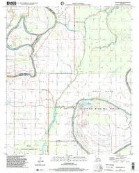
1998 Map of Indian Lake
USGS Topo · Published 2002About this map
Tensas River National Wildlife Refuge and the Big Lake State Wildlife Management Area dominate this section of the Louisiana delta, where the boundary between Madison Parish and Franklin Parish follows the winding path of Bayou Macon. The landscape is defined by the hydrologic complexity of the Tensas basin, featuring numerous oxbows and backwaters like Indian Lake, Africa Lake, and Buck Lake. This late-twentieth-century survey illustrates the region's character as a managed wilderness, where human infrastructure is limited to features like a small Landing Strip and a Boat Ramp near the Bayou Macon Cut-off. Extensive Spoil Banks along several waterways indicate the history of dredging and water management required to navigate and drain this alluvial terrain. The presence of Bakers Brake and Chain Lake underscores the seasonally flooded, low-lying nature of the bottomlands before they reach the main channel of the Tensas River.
Find a feature on this map
19 named features on this map. Tap any name to fly to it.
Don’t see what you’re looking for? This feature index may not catch every label — zoom into the map to look around manually.
Map Details
Editions of this 1998 Indian Lake Map
This is the sole edition of this map. No revisions or reprints were ever made.
Other maps of this area

1935 · Winnsboro
USGS Topo · 1:62,500

1935 · Baskinton
USGS Topo · 1:62,500

1935 · Waverly
USGS Topo · 1:62,500

1935 · Shackleford Lake
USGS Topo · 1:62,500

1955 · Jackson
USGS Topo · 1:250,000

1958 · Baskinton
USGS Topo · 1:62,500

1958 · Shackleford Lake
USGS Topo · 1:62,500

1958 · Winnsboro
USGS Topo · 1:62,500

1961 · Jackson
USGS Topo · 1:250,000

1961 · Waverly
USGS Topo · 1:62,500