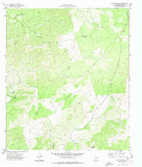
1974 Map of Indian Mountain
USGS Topo · Published 1977About this map
Stagecoach Waterhole and the high ground of the Edwards Plateau dominate this mid-1970s landscape, where the seasonal hydrology of the Texas Hill Country is on full display. The area is defined by complex drainage systems, including the headwaters of Bluff Creek and Cave Creek, which carve through the limestone terrain toward the Nueces River in the southwest corner. The presence of numerous Jeep Trails and a remote Landing Strip suggests a landscape of large private ranches and limited public access, characteristic of this portion of Edwards County. To the south, Indian Mountain and Black Mountain rise as prominent landmarks above the winding path of Dry Sycamore Creek. This survey captures a specific moment of rural land management, recording isolated infrastructure like a lone Tank and reliable water sources such as Cherry Spring that have long dictated the utility of this arid country.
Find a feature on this map
13 named features on this map. Tap any name to fly to it.
Don’t see what you’re looking for? This feature index may not catch every label — zoom into the map to look around manually.
Map Details
Editions of this 1974 Indian Mountain Map
2 editions found
Other maps of this area

1893 · Nueces
USGS Topo · 1:125,000

1896 · Nueces
USGS Topo · 1:125,000

1944 · Barksdale
USGS Topo · 1:62,500

1944 · Indian Creek
USGS Topo · 1:62,500

1944 · Indian Mountain
USGS Topo · 1:62,500

1947 · Hackberry
USGS Topo · 1:62,500

1958 · Del Rio
USGS Topo · 1:250,000

1964 · Del Rio
USGS Topo · 1:250,000
1967 · Indian Mountain
USGS Topo · 1:24,000
1974 · Twomile Draw
USGS Topo · 1:24,000