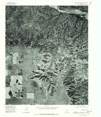
1976 Map of Indian Peak SW
USGS Topo · Published 1978About this map
Prairie Dog Town Fork Red River snakes across the northern edge of this West Texas landscape, as documented by a U.S. Geological Survey orthophotograph based on 1976 aerial imagery. The terrain is defined by the stark contrast between the alluvial plains to the west and the deeply eroded breaks of the Indian Peak area to the east. This transition from flat agricultural or grazing lands to the complex drainage patterns of Indian Creek illustrates the persistent geological forces shaping the Panhandle region. The map provides a raw, photographic record of the land surface before further modern modification, capturing the exact state of natural drainages and vegetation during the mid-1970s.
Find a feature on this map
3 named features on this map. Tap any name to fly to it.
Don’t see what you’re looking for? This feature index may not catch every label — zoom into the map to look around manually.
Map Details
Editions of this 1976 Indian Peak SW Map
This is the sole edition of this map. No revisions or reprints were ever made.
Other maps of this area

1954 · Plainview
USGS Topo · 1:250,000

1958 · Plainview
USGS Topo · 1:250,000

1960 · Indian Peak
USGS Topo · 1:62,500

1965 · Ross Canyon
USGS Topo · 1:24,000

1965 · Big Betty Reservoir
USGS Topo · 1:24,000

1965 · Silverton
USGS Topo · 1:24,000

1967 · Hay Lake
USGS Topo · 1:24,000

1967 · Lake Theo
USGS Topo · 1:24,000
1976 · Indian Peak NW
USGS Topo · 1:24,000
1976 · Indian Peak NE
USGS Topo · 1:24,000