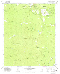
1977 Map of Indian Pine
USGS Topo · Published 1978About this map
The Mogollon Rim escarpment dominates this Arizona high-country landscape, marking a sharp topographic divide between the Sitgreaves National Forest and the Fort Apache Indian Reservation. Settlements such as Pinetop and Indian Pine sit at the northern edge of the reservation boundary, where the transition from forest to lower canyons begins. The map details a complex network of seasonal water sources and tanks, including Pine Lake and Hansen Tank, which supported the region's ranching operations at places like Amos Ranch and Cooley Ranch. South of the rim, the terrain drops into a series of deep drainages including First Hollow, Black Canyon, and Post Office Canyon. Local infrastructure of the late 1970s is evidenced by the Radio Facility, several Cinder Pits, and established recreation sites like the Pinetop Lakes Country Club.
Find a feature on this map
67 named features on this map. Tap any name to fly to it.
Don’t see what you’re looking for? This feature index may not catch every label — zoom into the map to look around manually.
Map Details
Editions of this 1977 Indian Pine Map
3 editions found
Other maps of this area

1886 · St Johns
USGS Topo · 1:250,000

1886 · Holbrook
USGS Topo · 1:250,000

1892 · St Johns
USGS Topo · 1:250,000

1893 · Holbrook
USGS Topo · 1:250,000

1954 · Holbrook
USGS Topo · 1:250,000

1954 · Clifton
USGS Topo · 1:250,000

1954 · Saint Johns
USGS Topo · 1:250,000

1954 · Mesa
USGS Topo · 1:250,000

1957 · Mesa
USGS Topo · 1:250,000

1957 · Holbrook
USGS Topo · 1:250,000