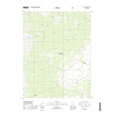
2019 Map of Indian Point
USGS Topo · Published 2019About this map
Grand Mesa National Forest defines this high-altitude landscape on the border of Mesa and Delta Counties. The map reveals an intricate network of water management features essential to the region's ranching and agricultural history, including the Kannah Cr Highline Ditch and the Juniata Ditch. High points like Indian Point and Lands End provide strategic overlooks above the complex drainage basins of Coal Creek Basin and Alkali Basin. The presence of Chambers Reservoir and Doughspoon Reservoir indicates the careful capture of snowmelt from the mesa's plateau. Evidence of early land use and access is found along the Indian Point Cutoff and remote outposts such as the Delta Cabin, illustrating how the forest's resources were historically navigated and utilized.
Find a feature on this map
46 named features on this map. Tap any name to fly to it.
Don’t see what you’re looking for? This feature index may not catch every label — zoom into the map to look around manually.
Map Details
Editions of this 2019 Indian Point Map
This is the sole edition of this map. No revisions or reprints were ever made.
Other maps of this area
1955 · Skyway
USGS Topo · 1:24,000
1956 · Moab
USGS Topo · 1:250,000

1956 · Grand Junction
USGS Topo · 1:250,000

1959 · Grand Junction
USGS Topo · 1:250,000
1959 · Moab
USGS Topo · 1:250,000
1960 · Moab
USGS Topo · 1:250,000

1960 · Grand Junction
USGS Topo · 1:250,000
1962 · Moab
USGS Topo · 1:250,000
1962 · Grand Junction
USGS Topo · 1:250,000
1962 · Lands End
USGS Topo · 1:24,000