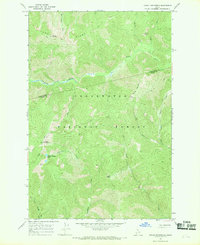
1966 Map of Indian Postoffice
USGS Topo · Published 1969About this map
Indian Postoffice serves as a prominent high-elevation landmark within the Clearwater National Forest, an area defined by its network of historic routes and ridgelines. Surveyed in the mid-1960s, this terrain preserves significant cultural markers such as the Lolo Trail and the nearby Rock Cairns. These features highlight the importance of high-country passage through the Bitterroot Mountains. The landscape is deeply dissected by drainages like Cayuse Creek and Postoffice Creek, with elevations rising toward Lunde Ridge and Spring Mountain. The inclusion of various Pack Trails and the Postoffice Trail indicates a reliance on foot and horse travel for forest management and transit during this era. High-altitude water sources, notably Indian Postoffice Lake, are mapped alongside geological points of interest like the Rock Garden and Deep Saddle, which mark natural crossings and vantage points used for generations.
Find a feature on this map
24 named features on this map. Tap any name to fly to it.
Don’t see what you’re looking for? This feature index may not catch every label — zoom into the map to look around manually.
Map Details
Editions of this 1966 Indian Postoffice Map
2 editions found
Other maps of this area

1911 · Lolo
USGS Topo · 1:250,000

1913 · Lolo
USGS Topo · 1:250,000

1956 · Hamilton
USGS Topo · 1:250,000

1959 · Hamilton
USGS Topo · 1:250,000

1960 · Hamilton
USGS Topo · 1:250,000

1964 · Hamilton
USGS Topo · 1:250,000

1965 · Gorman Hill
USGS Topo · 1:24,000

1965 · Horseshoe Lake
USGS Topo · 1:24,000
1966 · Rhodes Peak
USGS Topo · 1:24,000
1966 · Bear Mountain
USGS Topo · 1:24,000