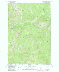
1966 Map of Indian Postoffice
USGS Topo · Published 1984About this map
Indian Postoffice serves as a prominent landmark on this mid-century survey of the Clearwater National Forest, where the boundary between Clearwater County and Idaho County follows the high ridgelines. The landscape is defined by its early transit corridors, specifically the historic Lolo Trail and the Pack Trail that traverse Lunde Ridge. These routes connect remote outposts like Bears Oil and Roots Camp and Lonesome Cove Camp, reflecting a period of wilderness management and seasonal occupancy. The presence of Rock Cairns near the post office site suggests long-standing human navigation through this high-country terrain. Hydrological features like Cayuse Creek and the small Indian Postoffice Lake punctuate the heavily forested slopes, while the Postoffice Trail provides a secondary link through the drainage toward Deep Saddle.
Find a feature on this map
26 named features on this map. Tap any name to fly to it.
Don’t see what you’re looking for? This feature index may not catch every label — zoom into the map to look around manually.
Map Details
Editions of this 1966 Indian Postoffice Map
2 editions found
Other maps of this area

1911 · Lolo
USGS Topo · 1:250,000

1913 · Lolo
USGS Topo · 1:250,000

1956 · Hamilton
USGS Topo · 1:250,000

1959 · Hamilton
USGS Topo · 1:250,000

1960 · Hamilton
USGS Topo · 1:250,000

1964 · Hamilton
USGS Topo · 1:250,000

1965 · Gorman Hill
USGS Topo · 1:24,000

1965 · Horseshoe Lake
USGS Topo · 1:24,000
1966 · Rhodes Peak
USGS Topo · 1:24,000
1966 · Bear Mountain
USGS Topo · 1:24,000