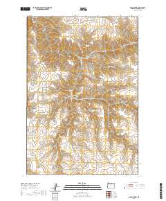
2020 Map of Indian Spring
USGS Topo · Published 2020About this map
Rattlesnake Butte stands as a prominent landmark in this deeply dissected portion of Gilliam County, where a complex network of drainages defines the high desert landscape. The terrain is characterized by steep-walled features such as Devils Canyon, Elbow Canyon, and Ferry Canyon, which carve through the volcanic plateau. Water sources are critical identifiers in this arid environment, evidenced by the numerous named points including Indian Spring, Freezeout Spring, and the curiously named Dipping Vat Spring, likely referencing historical livestock management practices in the region. The map captures a landscape largely shaped by seasonal water flow and ranching history, with remote routes like Ajax Ln and Seales Rd providing the only modern access through the intricate system of canyons such as Rose Briar Canyon and Shellrock Canyon.
Find a feature on this map
35 named features on this map. Tap any name to fly to it.
Don’t see what you’re looking for? This feature index may not catch every label — zoom into the map to look around manually.
Map Details
Editions of this 2020 Indian Spring Map
This is the sole edition of this map. No revisions or reprints were ever made.
Other maps of this area

1916 · Condon
USGS Topo · 1:125,000

1953 · The Dalles
USGS Topo · 1:250,000

1956 · The Dalles
USGS Topo · 1:250,000

1957 · The Dalles
USGS Topo · 1:250,000

1970 · Devils Backbone
USGS Topo · 1:24,000

1970 · Igo Butte
USGS Topo · 1:24,000
1970 · Schott Canyon
USGS Topo · 1:24,000

1970 · Indian Cove
USGS Topo · 1:24,000
1970 · Shoestring Ridge
USGS Topo · 1:24,000
1970 · Esau Canyon
USGS Topo · 1:24,000