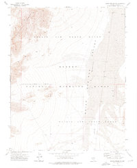
1973 Map of Indian Springs NW
USGS Topo · Published 1976About this map
Nellis Air Force Range dominates this corner of Clark County, defining a landscape utilized for military training and conservation in the early 1970s. The map illustrates a strictly controlled territory where the high terrain of the Spotted Range drops off into the broad expanse of Desert Valley. This arid basin transitions into the Indian Springs Valley (Depression), a low-lying area punctuated by numerous targets and lookout towers associated with the range's operations. Portions of the land are also designated as a National Wildlife Refuge, showcasing the dual-purpose management of this high-desert environment. Remnants of human activity are minimal, represented by an isolated Landing Strip and a rugged Jeep Tr that provide the only ground access through the restricted Military Reservation Boundary.
Find a feature on this map
13 named features on this map. Tap any name to fly to it.
Don’t see what you’re looking for? This feature index may not catch every label — zoom into the map to look around manually.
Map Details
Editions of this 1973 Indian Springs NW Map
This is the sole edition of this map. No revisions or reprints were ever made.
Other maps of this area

1907 · Las Vegas
USGS Topo · 1:250,000

1908 · Las Vegas
USGS Topo · 1:250,000

1942 · Indian Spring
USGS Topo · 1:125,000

1952 · Mercury
USGS Topo · 1:62,500
1952 · Frenchman Lake
USGS Topo · 1:62,500

1954 · Las Vegas
USGS Topo · 1:250,000

1957 · Las Vegas
USGS Topo · 1:250,000

1959 · Las Vegas
USGS Topo · 1:250,000

1962 · Las Vegas
USGS Topo · 1:250,000
1973 · Heavens Well
USGS Topo · 1:24,000