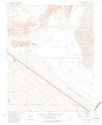
1973 Map of Indian Springs SE
USGS Topo · Published 1982About this map
The Pintwater Range dominates the western portion of this 1970s landscape, providing a stark topographical contrast to the expansive Desert Depression and Three Lakes Depression to the east. This area is defined by its restricted status, primarily falling within the Nellis Air Force Range and the National Wildlife Range. The convergence of military testing and environmental conservation is evident in the sparse but specific infrastructure scattered across the desert floor, including a Beacon, a Substation, and several Bunkers.
Find a feature on this map
22 named features on this map. Tap any name to fly to it.
Don’t see what you’re looking for? This feature index may not catch every label — zoom into the map to look around manually.
Map Details
Editions of this 1973 Indian Springs SE Map
3 editions found
Other maps of this area

1907 · Las Vegas
USGS Topo · 1:250,000

1908 · Las Vegas
USGS Topo · 1:250,000

1942 · Indian Spring
USGS Topo · 1:125,000

1945 · Sheep Range
USGS Topo · 1:125,000

1952 · Corn Creek Springs
USGS Topo · 1:62,500

1954 · Las Vegas
USGS Topo · 1:250,000

1957 · Las Vegas
USGS Topo · 1:250,000

1957 · Charleston Peak
USGS Topo · 1:62,500

1959 · Las Vegas
USGS Topo · 1:250,000

1962 · Las Vegas
USGS Topo · 1:250,000