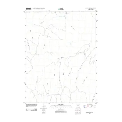
2010 Map of Indian Valley
USGS Topo · Published 2010About this map
Indian Valley and the surrounding high country of Rio Blanco County are defined by an intricate network of drainage channels and ridges. The presence of an Oil Well along Michaels Draw reflects the industrial activity in this part of western Colorado, where energy resource extraction sits alongside the traditional ranching geography. The terrain is marked by prominent features like Colorow Mountain and Horse Ridge, which divide the various branches of the Tschuddi drainage system, including West Tschuddi Gulch and Middle Tschuddi Gulch. Transport through this arid landscape is maintained via a sparse network of county roads, such as County Rd-77, which follows the contours of the gulches. Water management and natural drainage are critical here, evidenced by the named waterways like Deep Channel Creek and the seasonal flows of Twin Wash.
Find a feature on this map
21 named features on this map. Tap any name to fly to it.
Don’t see what you’re looking for? This feature index may not catch every label — zoom into the map to look around manually.
Map Details
Editions of this 2010 Indian Valley Map
This is the sole edition of this map. No revisions or reprints were ever made.
Other maps of this area

1907 · White River
USGS Topo · 1:125,000

1910 · White River
USGS Topo · 1:125,000

1954 · Vernal
USGS Topo · 1:250,000

1958 · Vernal
USGS Topo · 1:250,000

1958 · Citadel Plateau
USGS Topo · 1:62,500

1960 · Vernal
USGS Topo · 1:250,000

1960 · Elk Springs
USGS Topo · 1:62,500
1966 · White Rock
USGS Topo · 1:24,000
1966 · Smizer Gulch
USGS Topo · 1:24,000
1966 · Buckskin Point
USGS Topo · 1:24,000