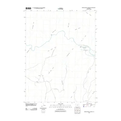
2010 Map of Indian Water Canyon
USGS Topo · Published 2010About this map
The Yampa River carves a dramatic path through this section of the high desert, defining the boundary and character of Dinosaur National Monument. The landscape is a network of deep drainage features and named landforms, from the evocative Vale of Tears and Thanksgiving Gorge to the heights of The Steps. Traces of early ranching and travel remain visible in the placement of Stubs Cabin and Spurgion Cabin, alongside the historic route of the Old Chuck Wagon Rd. This 2010 survey illustrates a region where modern recreation at Deerlodge Park and the Deerlodge Park Campground meets a primitive landscape of gulches and flats. The terrain is marked by significant features like Indian Water Canyon and Disappointment Draw, which tell the story of a challenging environment shaped by seasonal water and long-standing cattle-driving routes.
Find a feature on this map
26 named features on this map. Tap any name to fly to it.
Don’t see what you’re looking for? This feature index may not catch every label — zoom into the map to look around manually.
Map Details
Editions of this 2010 Indian Water Canyon Map
This is the sole edition of this map. No revisions or reprints were ever made.
Other maps of this area

1907 · Rangely
USGS Topo · 1:125,000

1907 · White River
USGS Topo · 1:125,000

1910 · White River
USGS Topo · 1:125,000

1910 · Rangely
USGS Topo · 1:125,000

1954 · Vernal
USGS Topo · 1:250,000

1958 · Vernal
USGS Topo · 1:250,000

1960 · Vernal
USGS Topo · 1:250,000

1960 · Elk Springs
USGS Topo · 1:62,500

1960 · Lone Mountain
USGS Topo · 1:62,500
1962 · M F Mountain
USGS Topo · 1:24,000