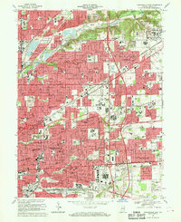
1967 Map of Indianapolis East
USGS Topo · Published 1970About this map
Fort Benjamin Harrison Military Reservation anchors the northeastern corner of this 1960s landscape, illustrating the intersection of military, industrial, and suburban expansion in Marion County. The eastern edge of Indianapolis is characterized by a dense grid of residential streets and numerous local schools, including Booth Tarkington Sch No 92 and Arlington Woods Sch No 99, reflecting mid-century population growth. Transport infrastructure is prominent, with the Norfolk and Western and Penn Central railroads cutting through neighborhoods toward the massive Hawthorne Yards. Small, long-established communities like Millersville and Brendonwood sit alongside newer developments like Avalon Hills. Natural features such as Fall Creek and Pogue's Run provide a counterpoint to the urban sprawl, winding through recreational spaces like the Hillcrest Country Club and Brookside Park.
Find a feature on this map
122 named features on this map. Tap any name to fly to it.
Don’t see what you’re looking for? This feature index may not catch every label — zoom into the map to look around manually.
Map Details
Editions of this 1967 Indianapolis East Map
Other maps of this area

1948 · Indianapolis East
USGS Topo · 1:24,000

1948 · Maywood
USGS Topo · 1:24,000

1948 · Beech Grove
USGS Topo · 1:24,000

1948 · Indianapolis West
USGS Topo · 1:24,000

1952 · Cumberland
USGS Topo · 1:24,000

1952 · Fishers
USGS Topo · 1:24,000

1952 · Carmel
USGS Topo · 1:24,000

1952 · Mc Cordsville
USGS Topo · 1:24,000

1953 · Acton
USGS Topo · 1:24,000

1953 · Cincinnati
USGS Topo · 1:250,000
Featured Places
- Indianapolis, IN
- Lawrence, Indianapolis
- Warren Park, Indianapolis
- Dawnbury, Indianapolis
- Brendonwood, Indianapolis