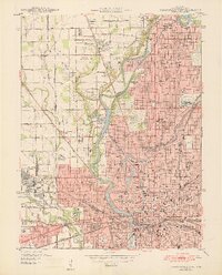
1948 Map of Indianapolis West
USGS Topo · Published 1948About this map
Indianapolis in the late 1940s is captured here as a dense urban core radiating outward into developing suburbs and industrial sectors. The landscape is defined by the winding course of the White River and Fall Creek, around which significant public institutions and landmarks are situated. Central to the city's identity at this time are massive facilities like the Indianapolis Motor Speedway in Speedway City and the sprawling Crown Hill Cemetery.
Find a feature on this map
83 named features on this map. Tap any name to fly to it.
Don’t see what you’re looking for? This feature index may not catch every label — zoom into the map to look around manually.
Map Details
Editions of this 1948 Indianapolis West Map
2 editions found
Other maps of this area

1948 · Indianapolis East
USGS Topo · 1:24,000

1948 · Maywood
USGS Topo · 1:24,000

1948 · Beech Grove
USGS Topo · 1:24,000

1948 · Indianapolis West
USGS Topo · 1:24,000

1952 · Fishers
USGS Topo · 1:24,000

1952 · Carmel
USGS Topo · 1:24,000

1953 · Bridgeport
USGS Topo · 1:24,000

1953 · Zionsville
USGS Topo · 1:24,000

1953 · Clermont
USGS Topo · 1:24,000

1953 · Indianapolis
USGS Topo · 1:250,000
Featured Places
- Indianapolis, IN
- Speedway, Indianapolis
- Meridian Hills, Indianapolis
- Rocky Ripple, Indianapolis
- Wynnedale, Indianapolis