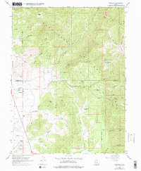
1967 Map of Indianola
USGS Topo · Published 1978About this map
Indianola sits at the base of the Manti-La Sal National Forest, where the high ridges of the Wasatch Plateau meet the drainage of Thistle Creek. This 1960s landscape, updated in the mid-1970s, captures a rural Utah community defined by its water sources and rugged topography. The presence of the Spencer Cem and several family-named landmarks like Poulson Well and Tidwell Spring provide valuable markers for genealogical research. The map illustrates a transitional geography between the high peaks like Browns Peak and the deeper valleys of the San Pitch River and San Pitch Canyon. Industrial activity is sparse but notable, including the Chelons Mine tucked into Hjorth Canyon and several gravel pits. A network of jeep trails and a prominent pipeline traverse the ridges, showing the early modern infrastructure crossing the Utah and Sanpete County line.
Find a feature on this map
47 named features on this map. Tap any name to fly to it.
Don’t see what you’re looking for? This feature index may not catch every label — zoom into the map to look around manually.
Map Details
Editions of this 1967 Indianola Map
3 editions found
Other maps of this area

1885 · Manti
USGS Topo · 1:250,000

1895 · Manti
USGS Topo · 1:250,000

1951 · Moroni
USGS Topo · 1:62,500

1952 · Santaquin Peak
USGS Topo · 1:62,500

1956 · Price
USGS Topo · 1:250,000

1960 · Price
USGS Topo · 1:250,000

1962 · Price
USGS Topo · 1:250,000

1965 · Fairview Lakes
USGS Topo · 1:24,000
1967 · Indianola
USGS Topo · 1:24,000
1967 · Mill Fork
USGS Topo · 1:24,000