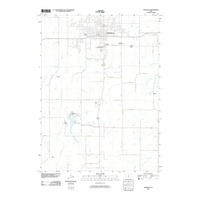
2010 Map of Indianola
USGS Topo · Published 2010About this map
Indianola serves as the central hub of this 2010 topographic survey, showcasing a landscape where civic expansion meets established rural roots. The city's northern grid is defined by landmarks like the Warren County Fairgrounds and the Indianola Post Office, while the southern reaches transition into the recreational and agricultural corridor of the South River valley. This area is notably dense with genealogical interest, containing the Independent Order of Odd Fellows Cemetery and the Indianola City Cemetery within the city limits, plus the outlying Randolph Cemetery and Hewitt Cemetery to the south and west.
Find a feature on this map
36 named features on this map. Tap any name to fly to it.
Don’t see what you’re looking for? This feature index may not catch every label — zoom into the map to look around manually.
Map Details
Editions of this 2010 Indianola Map
This is the sole edition of this map. No revisions or reprints were ever made.
Other maps of this area

1910 · Milo
USGS Topo · 1:62,500

1918 · Chariton
USGS Topo · 1:62,500

1931 · Indianola
USGS Topo · 1:62,500

1950 · New Virginia
USGS Topo · 1:62,500

1952 · New Virginia
USGS Topo · 1:62,500

1954 · Des Moines
USGS Topo · 1:250,000

1956 · Des Moines
USGS Topo · 1:250,000

1957 · Des Moines
USGS Topo · 1:250,000

1965 · Milo
USGS Topo · 1:24,000
1965 · Hartford
USGS Topo · 1:24,000